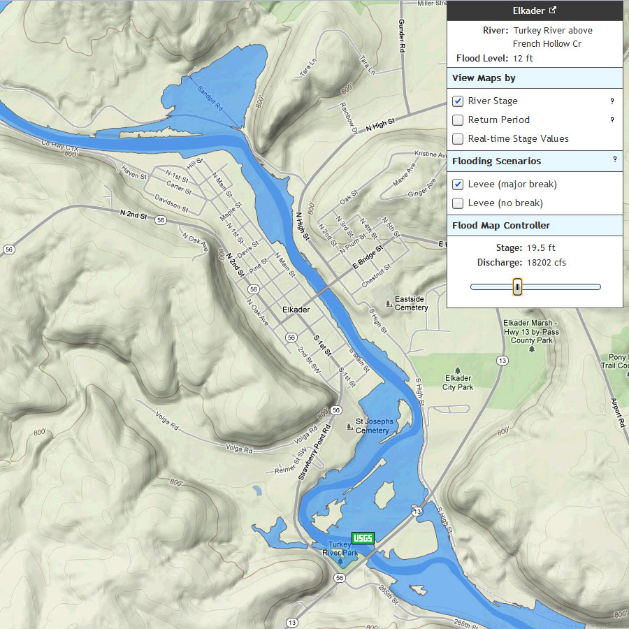
The City of Monona, a member of the Turkey River Watershed Management Authority, has been approved to move forward with a project to redirect storm water runoff associated with the Monona City Aquatic Center. The funding was secured through a new program related to Iowa’s State Revolving Fund (SRF).  Monona applied to SRF in July of 2013 and received final approval in October. … Read more ›

GUNDER —Ron McCartney wears several hats with the Turkey River Watershed Management Authority. He is WMA secretary/treasurer, a Clayton County supervisor, and he farms land impacted by Turkey River flooding.

“This is completely different than anything we’ve done in the past,” said McCartney. “We’ve had a lot of water quality projects in this area, but this is the first time someone is taking a shot to see if it’s possible to affect water flow.… Read more ›

The Turkey River Watershed Management Authority is working on a five-year pilot demonstration project with IIHR – Hydroscience & Engineering at the University of Iowa and the Iowa Flood Center.

The project’s goal is to create state-of-the-art hydrological modeling of the water flowing through the Turkey River Watershed, said Lora Friest, executive director of Northeast Iowa RC&D in Postville.

The Iowa Flood Center has put its own stream stage sensors at 11 locations in the watershed and at other locations.… Read more ›

The Turkey River Watershed Management Authority met on March 28th at the YMCA in Postville. Approximately 60 attendees, including the TRWMA Board, listened to presentations given by NRCS Iowa State Conservationist, Jay Mar and Larry Weber, the Director of IIHR Hydroscience and Engineering and Iowa Flood Center.

Before the presentations, the TRWMA Board accepted a recommendation from the TRWMA Executive Committee and voted unanimously to recommend the Iowa Flood Center select Otter Creek in Fayette County for modeling.… Read more ›

The National Aeronautic and Space Administration plans to collect Iowa precipitation data this spring that could launch a new era of timely and accurate flood predictions. The data will help scientists understand how satellite radar images relate to actual rainfall so they can more accurately predict rainfall amounts and flood events, said Vitold Krajewski, director of the Iowa Flood Center, which is partnering with NASA on the Iowa Flood Study project. Sara Steussy, a research support coordinator at the flood center, said most of the instruments will be deployed in a line running roughly from Waterloo to Iowa City, with the most powerful portable radar unit situated southwest of Waterloo. That radar unit will fill a gap in coverage of the four National Weather Service radars operating in Iowa, Petersen said. A second cluster of about 20 rain gauges with soil moisture sensors and two smaller portable radars will be deployed in the Turkey River Valley, Steussy said.

The Iowa Flood Center has announced that the Soap and Chequest Creek, Turkey River, and Upper Cedar River watersheds will each receive a $1.5 million grant for construction of watershed improvement projects to support flood mitigation, such as farm ponds, wetlands, and floodplain easements in a targeted area of the watershed. The grant, provided with funding from the U.S. Department of Housing and Urban Development, is part of the Iowa Watersheds Project, an effort of the Iowa Flood Center at the University of Iowa.… Read more ›

Innovative research on northeast Iowa’s Turkey River may herald a breakthrough in state efforts to mitigate future flood damage.

“This really is the first time that hydro modeling has been done in advance of project implementation to get the highest value for the investment,” said Larry Weber, director of IIHR — Hydroscience & Engineering, the parent organization of the Iowa Flood Center.… Read more ›

The Iowa Flood Center and IIHR—Hydroscience & Engineering (IIHR) at the University of Iowa have announced the selection of four watersheds for the initial phase of the Iowa Watershed Projects.

The selected entities and respective watersheds include:

  • Clayton County for the Turkey River.
  • Dallas County for the Middle/South Raccoon River.
  • Davis County for Soap Creek and Chequest Creek.
  • Floyd County for the Upper Cedar River.
Read more ›

During recent flood events, many Iowans have found it difficult to relate flood forecast information to risks within their community. To help translate flood forecasting information into an easy-to-use format, the Iowa Flood Center is developing flood inundation maps for select Iowa communities.

IFC researchers are creating physics-based computer models to predict how a flood wave travels through urban floodplains. These high-resolution models can illustrate the extent of flooding under different conditions allowing Iowans to see how predicted flood levels could affect their property, and in turn helping them make informed decisions.… Read more ›

Two Eleven new bridge sensors, which use sonar to detect the height of water under a bridge and automatically relay that information over the cell phone network, have been installed on the Turkey and Volga Rivers (also Crane Creek, Roberts Creek, Little Turkey RIver, and Otter Creek). The sensors were built by students at the Iowa Flood Center at the University of Iowa toprovide real-time stage data that can be used by emergency personnel in Clayton and Fayettte counties.Read more ›